 Gaurav Seth
Gaurav is CEO and Founder of PierSight. He spent nine years at Indian Space Research Organization developing several SAR applications for EO and multiplanetary missions
 Vinit Bansal
Vinit is Cofounder and CTO of PierSight. He brings over nine years of experience in prototyping and commercialization of space and defense tech.
Table of Contents
- Let’s Cry Over Spilt Oil
- Deepwater Horizon Oil Spill
- Frequency of Oil Spills
- What happens when oil leaks into the ocean?
- Ecological impact
- Economic impacts
- Plan. Preserve. Protect.
- Current Surveillance Standards
- Synthetic Aperture Radars for Oil Spill Detection
- Why SAR for Oil Spill Detection?
- Persistent Monitoring via a Constellation of SAR Satellites
- How PierSight’s Constellation Can Detect Oil Spills
- Challenges in SAR-based Oil Spill Detection
- In Conclusion

Canonical URL
Do not index
Tags
Imagine if all the bathtubs in the US were filled with oil…and all that oil was released into the Gulf of Mexico. 134 million gallons. That’s how much oil was released in the massive 87-day-long Deepwater spill in 2010.
In a recent environmental crisis, Trinidad and Tobago faced a significant challenge when an oil spill occurred due to a capsized barge first noticed on Feb 7, 2024. The spill has yet to be contained, with oil spreading up to 160 km away from Tobago's shores. This incident has prompted an urgent response from neighboring Caribbean nations, as Trinidad alerted Venezuela and Grenada about the potential impact on their coasts.
The spill highlights the persistent threat oil spills pose to marine ecosystems, local economies, and human health, underscoring the need for effective detection, monitoring, and rapid response measures to mitigate environmental damage.
In this article, we look at oil spills and their impact. We examine existing systems for detection and monitoring and their limitations. Lastly, we will present solutions that could help government agencies and organizations that work on ocean conservation combat oil spills more effectively.
Let’s Cry Over Spilt Oil
Deepwater Horizon Oil Spill
On April 20, 2010, an explosion in The Deepwater Horizon oil rig released 4 million barrels of oil into the ocean. It caused the death of 11 workers and became the largest oil spill in history. The cascading effects of this calamity are relevant to date.
During drilling, the concrete core meant to seal the well ruptured, causing natural gas to rise through the rig and catch fire. Oil started sputtering into the ocean – 60,000 barrels per day for almost three months.
Since the rig sank two days after the explosion, countermeasures to prevent any spilling were also disabled. On September 17, the well was sealed after the spill affected over 70,000 square miles of ocean.
The coasts of Texas, Louisiana, Mississippi, Alabama, and Florida were the worst affected by this event. All beaches had to be closed for fishing and tourism, affecting local livelihood and devastating marine life.
Frequency of Oil Spills
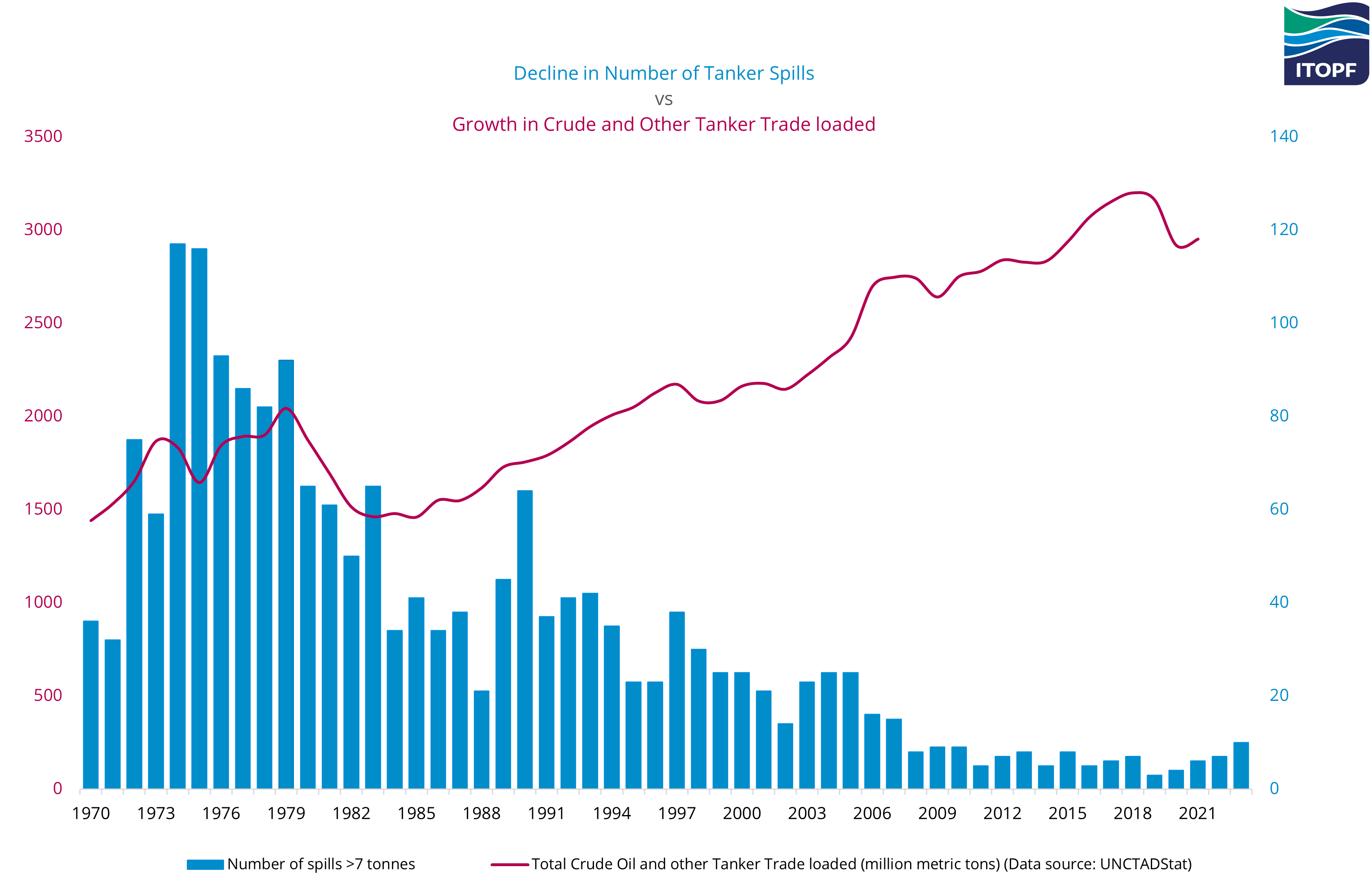
An interesting chart published by ITOPF indicates oil spills by tankers are declining despite an increasing volume of trade through the sea. That is good news.
But here’s the thing - oil spills are typically self-reported, and usually, this is when there’s an accident involving a tanker.
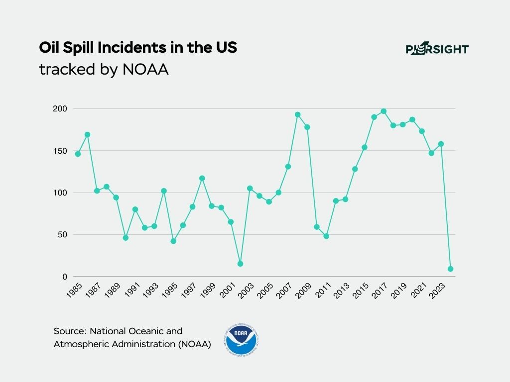
The National Oceanic and Atmospheric Administration (NOAA) maintains a tracker of oil spill incidents. In 2023, there were 158 reported offshore and onshore incidents in the US. Globally, the number of incidents would be in the thousands.
What happens when oil leaks into the ocean?
Ecological impact
Once oil is exposed to oceanic water, it breaks down in multiple stages, each impacting marine life differently. These include the formation of a surface plume, evaporation, and dispersion followed by biodegradation. Oil degradation also depends on the salinity of water, type of oil, wind, weather, tides, temperature, etc.
- The surface plume is a low-density layer of oil over the water's surface. This layer cuts off gaseous and light exchange, impacting aquatic life on the surface. It mainly affects Sargassum, or seagrass, an algae crucial to aquatic food systems.
As a floating habitat, seagrass provides refuge and breeding grounds for fishes, marine birds, crabs, and shrimp. Oil deposits poison and debilitate such organisms, the effects of which snowball up the food chain.
- Surface plumes also get trapped in the feathers of seabirds that rest in these habitats, restricting their flight and drowning them. The oil blemishes the insulating layers on these birds’ feathers, or the birds ingest the oil.
- Turtles, seabirds, and dolphins inhale toxic oil vapors released from the spill. They also often ingest the oil, contaminating the respiratory and reproductive systems of turtles, seabirds, and dolphins.
The Deepwater Horizon oil spill caused the death of 65,000 turtles in 2010 and affected up to 4 times more of the entire turtle population that was in migration for breeding.
- Considering the delicate interconnectedness of food chains, higher predators also suffer by consuming contaminated prey or starving from a lack of prey.
Economic impacts
The first livelihoods to be impacted depend on the tourism and fishing industries. Contamination threatens coastal areas, causing short-term disruptions in recreational activities and long-term economic repercussions for fisher folk.
Physical contamination directly impacts fishing and mariculture, disrupting stocks and food security. Shipyards, ports, harbors, and traffic passing through these areas are affected. Enterprises requiring seawater - such as salt production - are also adversely affected.
Operations must be terminated or suspended until cleanup ends, which is often a months-long endeavor. Tourism and fisheries suffer long-term consequences, mainly since restoration and adaptation are expensive. A well-executed contingency plan tailored to the area's economic profile and industries associated with it can assist in limiting damage and fast-track rehabilitation efforts.
The Deepwater Horizon oil spill had a significant economic impact from 2010 to 2020. It led to the loss of over 25,000 jobs, a $2.3 billion decrease in industry output, and a $700 million decrease in labor income due to lost commercial fishing revenues and reduced recreational fishing expenditures.
Plan. Preserve. Protect.
In light of the devastating impacts that oil spills can inflict on our oceans and ecosystems, it is imperative to consider prevention and response strategies. Realistically, accidents, human errors, and other unforeseen events can still happen, so a contingency plan is essential.
If a spill occurs, early detection can minimize the damage. The prolonged presence of oil in the ocean means that marine wildlife is exposed for longer, leading to more severe consequences.
Current Surveillance Standards
Efficient surveillance is crucial for early detection and rapid response to oil spills.
So, what system is in place to track spills before they occur and alert authorities?
None. Or rather, none that are effective. Surprisingly, discovery relies on stakeholders informing the authorities and requesting assistance.
Not all oil spills are accidental. They are often triggered by malicious agents such as pirates and other offenders. Surveillance and regulatory detection become crucial for mitigating the aftereffects in such cases.
Currently, there are two broad approaches to detecting and monitoring oil spills.
- Remote Sensing Techniques:
- Satellite Imagery: Utilizes optical, radar (like SAR), and thermal sensors aboard satellites to detect oil spills from space. Optical sensors are limited by cloud cover and darkness, while radar sensors can penetrate these obstacles.
- Aerial Surveillance: Aircraft equipped with sensors such as Side-Looking Airborne Radar (SLAR), infrared, and ultraviolet imaging can cover large areas quickly, providing real-time data.
- UAVs (Unmanned Aerial Vehicles): Drones equipped with cameras and other sensors can monitor specific areas more frequently and at a lower cost than crewed aircraft.
- In-situ Monitoring Techniques:
- Vessel-Based Surveys: Ships equipped with various sensors and sampling equipment can provide detailed, localized information about an oil spill, including thickness, extent, and type of oil.
- Buoys and Drifters: These are deployed in the water and can carry sensors that relay information about oil presence back to monitoring stations.
However, these methods and technologies have significant limitations. Remote sensing struggles with detection because of the ocean's vastness and the inability of aircraft & UAVs to cover the entire expanse. Present-day Earth observation satellites are optimized for taking images of specific locations and not scanning vast areas. Essentially, these solutions cannot persistently monitor 100% of the oceans.
Synthetic Aperture Radars for Oil Spill Detection
In our search for the optimal surveillance technology, let's explore a particular solution – Synthetic Aperture Radar (SAR).
Synthetic Aperture Radar (SAR) uses microwave frequency signals to create detailed images of the Earth's surface. It sends out pulses of radio waves and measures the reflected waves (backscatter), allowing the system to create a high-resolution image.
In the case of oil spills, SAR can trace the extent of leaks on oceanic water, the coast, and even underwater. It can also trace wildlife affected by the spill with real-time monitoring and reliable data, aiding 24X7 rescue efforts.
Why SAR for Oil Spill Detection?
- Operational Under All Weather Conditions: SAR can penetrate cloud cover and is not dependent on sunlight, making it ideal for continuously monitoring marine environments.
- Surface Roughness Sensitivity: SAR is sensitive to variations in surface roughness. Since oil smooths the surface of water, oil slicks appear as dark patches in SAR images, contrasting with the surrounding water.
- Large Area Coverage: SAR can cover vast ocean areas in a single pass, allowing for efficient monitoring of potential spill sites and rapid response.
Persistent Monitoring via a Constellation of SAR Satellites
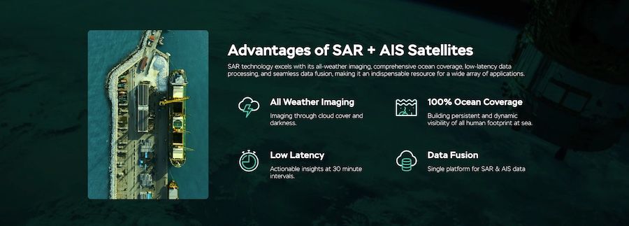
We are building a constellation of backpack-sized SAR & AIS satellites for persistent ocean monitoring. Key characteristics of our data:
- Persistent Monitoring: With 100% ocean coverage and a 30-minute revisit time, we enable authorities to get near real-time information.
- High Resolution: SAR can produce high-resolution images due to its ability to synthesize a large antenna aperture.
- All-weather Capability: Microwave signals can penetrate clouds and are not affected by lighting conditions, enabling SAR to capture images in all weather, day or night.
At the start of this article, we mentioned the recent oil spill in Trinidad and Tobago. Sentinel-1, a SAR satellite operated by the European Space Agency (ESA), captured the oil spill. While it was able to track the oil spill, with a revisit time of 12 days, the data cannot aid in real-time operations.
PierSight’s solution would provide a revisit time as low as 30 minutes, allowing teams involved in cleanup and conservation to access near real-time data.
How PierSight’s Constellation Can Detect Oil Spills
- Image Acquisition: Our constellation of SAR satellites continuously captures ocean images.
- Image Processing: The raw SAR images are processed to enhance features relevant to oil spill detection, such as smoothing the water surface.
- Dark Spot Detection: Algorithms identify dark spots in the SAR images, which may indicate oil slicks. However, not all dark spots are oil spills; they could also be due to natural phenomena like calm waters or algal blooms.
- Feature Analysis: Machine learning algorithms analyze characteristics of the detected dark spots, such as shape, size, texture, and context within the image, to distinguish oil spills from other phenomena.
- Verification and Classification: Further analysis, sometimes incorporating data from other sources (like optical satellite imagery or field reports), verifies the detected spills. Machine learning models can also classify the type of oil and estimate the spill's extent.
Challenges in SAR-based Oil Spill Detection
While SAR satellites can definitely help, they also have limitations.
- False Positives: Natural phenomena like calm sea regions, rain cells, and algal blooms can mimic the appearance of oil spills in SAR images, leading to false positives.
- Oil Slick Thickness Estimation: While SAR can detect the presence of oil on the water surface, estimating the thickness of the oil slick is challenging and typically requires additional data or models.
- Small Spills Detection: Detecting tiny spills or thin oil films remains challenging due to the resolution limits of SAR and the complex dynamics of oil on the water surface.
But some of these limitations can be overcome through advancements that technologists, including our team at PierSight, are actively working on. Research continues to enhance the capabilities of SAR for oil spill detection, focusing on:
- Improved Algorithms: Developing more sophisticated algorithms and machine learning models to better differentiate between oil spills and false positives.
- Multi-Sensor Integration: Combining SAR data with information from optical sensors and other sources to improve detection accuracy and provide comprehensive monitoring solutions.
- Real-Time Processing: Advancing processing techniques to enable near-real-time detection and reporting of oil spills, facilitating quicker response to mitigate environmental impact.
In Conclusion
We believe persistent monitoring is a step-function change in Earth Observation and an urgent need to protect the planet. The ocean is a treasure house of life and resources. Our planet depends on the oceans; scientific evidence points to them as the originator of all life, and without them, everything will perish.
At PierSight, we aim to build a SAR constellation to address several issues in the maritime domain - environmental problems being one of them, including but not limited to oil spills.
If you work at an organization or government agency focusing on detecting and monitoring oil spills, get in touch to learn more about relevant products and solutions.
Written by
Gaurav Seth
Gaurav is CEO and Founder of PierSight. He spent nine years at Indian Space Research Organization developing several SAR applications for EO and multiplanetary missions
Written by
Vinit Bansal
Vinit is Cofounder and CTO of PierSight. He brings over nine years of experience in prototyping and commercialization of space and defense tech.

