Protecting Exclusive Economic Zones Through Persistent Monitoring
We explore the current methods for protecting Exclusive Economic Zones and their limitations. Further, we present a solution in the form of a satellite constellation that provides persistent ocean monitoring.
Gaurav is CEO and Founder of PierSight. He spent nine years at Indian Space Research Organization developing several SAR applications for EO and multiplanetary missions
In 2008, India witnessed one of the worst terrorist attacks in the country’s history. The attacks occurred in Mumbai, India’s financial capital, and drew a tragically high death and injury toll. The terrorists infiltrated India by sea.
In 2023, a commercial oil tanker on its way to India with an Indian crew was attacked by a drone in the southern Red Sea. Thankfully, there were no casualties.
There is a “large presence” of Chinese vessels in the Indian Ocean Region, and India keeps a “very close watch” on the developments in the region to protect and preserve its national interests in the maritime domain.Navy Chief Admiral R Hari Kumar
These events reveal that, by all accounts, the vastness of the oceans makes it challenging to monitor and surveil.
This article discusses the current methods for protecting Exclusive Economic Zones and their limitations. Further, it presents a solution in the form of a satellite constellation that provides persistent ocean monitoring.
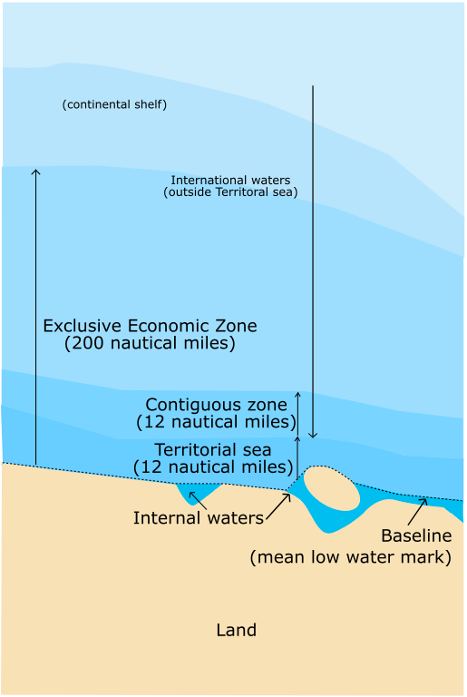
The United Nations Convention on the Law of the Sea (UNCLOS) defines an Exclusive Economic Zone (EEZ) as generally extending 200 nautical miles from shore, “within which the coastal state has the right to explore and exploit, and the responsibility to conserve and manage, both living and non-living resources.”
Monitoring maritime activity has always been challenging. The threats are extensive – Illegal, Unreported, and Unregulated (IUU) fishing, human trafficking, terrorism, oil spills, hazardous waste dumping, compliance headaches, fraud, embargo violations, and thousands of ships charting their course simultaneously at any moment.
Current surveillance methods could be categorized as:
aerial: helicopters, aircraft, drones
sea: warships, coast guard vessels
terrestrial: ground-based radar detection
orbital: traditional electro-optical satellites
Ships are also equipped with AIS or the Automatic Identification System. It transmits, among other things, a ship’s position at regular intervals so that its location can be monitored by other ships and any relevant land-based authority.
Most large ships, including commercial fishing, are legally required to be equipped with AIS. But like most technologies, AIS has limitations.
AIS receivers listen to broadcasts but cannot really “see” ships. Transponders can be switched off or spoofed. This loophole has already been exploited by bad actors, as revealed when Russia evaded oil sanctions in 2023 by spoofing the location of an oil tanker. They were able to manipulate their tracking equipment and transmit false information.
More recently, it was reported that the Indonesian coastguard intercepted a Chinese research vessel - Xiang Yang Hong 03 - on its way to Maldives. The reason for this action was the switching off the AIS transponder thrice while in Indonesia EEZ.
The implications of such a glaring technical gap for national and material security become alarmingly apparent, don’t they?
Active Threats to Exclusive Economic Zones
A country’s size is usually inversely proportional to the security of its Exclusive Economic Zone. Monitoring using conventional means is impossible for a country like India, with 2.3 million square kilometers of EEZ. Many countries also lack adequate resource allocation for monitoring and enforcement efforts along coastal borders.
According to data from WorldAtlas, here are the top 10 countries by EEZ area. India ranks No.18 on the list.
Rank
Country
Exclusive Economic Zone Area ( km2)
1
France
11,691,000
2
United States
11,351,000
3
Australia
8,505,348
4
Russia
7,566,673
5
United Kingdom
6,805,586
6
Indonesia
6,159,032
7
Canada
5,599,077
8
Japan
4,479,388
9
New Zealand
4,083,744
10
Chile
3,681,989
Violating these critical borders impacts national security, trade regulations, and immigration control. At the very minimum, countries with breached and unmonitored EEZ experience:
Illegal, Unregulated, and Unreported Fishing
Human trafficking and smuggling via undocumented vessels on un-surveilled seas.
Inadequate information for carrying out search and rescue operations.
Insufficient ability to cooperate with international partners to maintain marine borders or carry out protective or conservation efforts.
Combat the evolving tactics of criminal and terrorist networks constantly using new routes and sophisticated technologies.
In other words, the need for fortifying the security of every country’s EEZ is more essential than ever before.
So, what are our options for optimizing maritime surveillance?
Two Words: Persistent Monitoring
Persistent Monitoring - CCTVs in the Sky
As the term suggests, persistent monitoring is the constant surveillance of a dynamic environment to keep track of all activity and movement. In maritime surveillance, the usage is obvious – to persistently monitor all human activity in near real-time.
This would require some very awake eyes in the sky - giant CCTV cameras in space.
Earth Observation (EO) satellites are these eyes in the sky. They are equipped with sensors to observe natural phenomena and human activity. Their applications range from weather and disaster monitoring to population and landscape shifts.
These satellites are typically in Low Earth Orbit (LEO) - usually between 450 km and 2,000 km above the surface. As such, they have a restricted field of view and require several satellites to cover the complete surface of the Earth. Enter constellations, tens or hundreds of satellites flying in defined formations.
However, they are limited when it comes to persistent monitoring:
They can’t image during nighttime or through clouds.
They require significant bandwidth to transmit images; with the number of images that would have to be captured, it’s impractical.
They have a limited field of view.
The role of CCTV cameras in reducing crime is well-known. The College of Policing in the UK indicates that CCTV is "associated with a statistically significant decrease in crime."
According to another study, “crime decreased by 13% in places with CCTV, compared to places without it. It also revealed that certain types of crime are affected by the presence of CCTV: drug-related crime decreased by 20%, and vehicle and property crime by 14%”.
As we like to put it across, to prevent and tackle illegal activities, “Persistence is all you need.”
Enter Synthetic Aperture Radar (SAR) Satellites
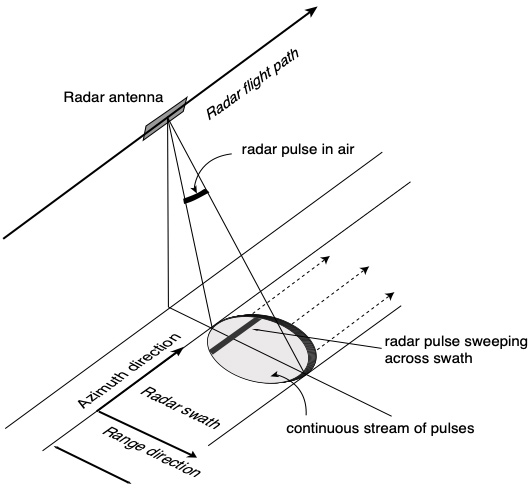
SAR is a technique for producing high-resolution images using a moving system (in this case, a satellite) equipped with a transmitter and antenna receiver. It emits electromagnetic signals toward the Earth's surface and then captures them as they bounce off. Sensors that record signal strength and time delay capture these reflected signals- also called backscatter. The data is then processed to give an image.
This transmitter-receiver system on a moving platform (including aerial platforms) creates an artificially expanded aperture. The larger the aperture, the better the radar.
Typically, the signals emitted are of the microwave wavelength. Microwave signals can seamlessly penetrate through obstructions such as clouds and operate during nighttime. The reflected signals are captured by antennas mounted on the satellite and processed to give an image of the surface. A significant advantage of SAR is that it can scan large swathes - widths of up to 500 km.
Further, metallic objects are highly reflective. A ship at sea shines bright like a star in the clear night sky in a SAR image, which is why SAR is ideal for imaging maritime environments.
With a constellation of SAR satellites, one could detect changes in near real-time in maritime environments. While AIS transponders could be turned off or their signals spoofed, ships can’t escape the all-seeing eyes of SAR satellites.
By now, the advantages of SAR should have become glaringly apparent. This brings us to our solution for persistent ocean monitoring.
PierSight - Constellation of SAR & AIS Satellites
PierSight is building a constellation of SAR & AIS satellites - eyes and ears in space. These will be the first ever satellites to have the means to receive broadcasts and verify if they are authentic.
That begs the question, why haven’t existing SAR satellites been employed in persistent surveillance?
Since SAR satellites have to generate electromagnetic signals and then receive and process them, they tend to be large - the size of a school bus. And they are expensive! Launching a constellation of these would be prohibitively expensive.
We’ve figured out how to build backpack-sized SAR satellites, shrinking them by a factor of 10 and bringing down the cost by six times. Of course, we’d be giving it away if we were to detail it out, but part of the solution was to lower the resolution. After all, we want persistent monitoring and not specific images. We’re looking at the bigger picture, not the finer details. Existing EO solutions in the market are focused on tasking - capturing particular images based on customer requests. As a result, they are higher resolution and can’t be employed for persistent surveillance.
Hence, we see PierSight as a solution that integrates with the existing ecosystem of Earth Observation satellites. PierSight is the first point for identifying anomalies or threats, after which another EO satellite can get a high-resolution image.
The constellation will comprise 30+ satellites orbiting the Earth, offering near real-time and persistent monitoring of 100% of the ocean.
While EEZ Protection is at the very core of our offerings, our constellation will cater to several organizations - private, government, and non-governmental - to solve the detection of illegal fishing, dark ships, oil spills, and other unlawful activities at sea. Further, we believe that new capabilities unlock benefits for ship liners in streamlining operations and compliance. At the same time, rich alternative maritime data could help insurance companies with risk assessment and hedge funds to discover new opportunities.
Learn more about PierSight’s offerings or contact our team to discuss various solutions for the maritime domain. If you’d like to help us build the future of SAR-based monitoring, check out our careers page.
Gaurav is CEO and Founder of PierSight. He spent nine years at Indian Space Research Organization developing several SAR applications for EO and multiplanetary missions
 Gaurav Seth
 Vinit Bansal